National Park
The creation of the Delta
The region of the Axios Delta once looked quite different from what we see today. Through the passage of time, its size and morphology have changed frequently, either due to natural processes or through human interventions.
About 24,000 years ago, the Thermaic gulf was land, drained by the rivers Axios, Gallikos, Aliakmon and Moglenitsas at Almopia. Then –about approximately 18,000 years ago, in the Holocene era– the sea level rose, due to the melting of the glaciers. Water came into the north, flooding the depths of the Thermaic and the entire flat area of the basin of Thessaloniki – Giannitsa, reaching until the mountain massifs to the north.
During the 5th century, the cities of Skydra and Pella were coastal. Historic evidence from that era manifests the accelerated evolution of the deltaic system of the four rivers. The estuaries of the rivers were considerably shifted and alluvia were rapidly deposited in the new estuaries. The Axios and the Gallikos formed an extended delta between Thessaloniki and Giannitsa, with a tendency to bisect the northern part of the sea gulf.
Within a few hundred years, the deltas of rivers Axios, Gallikos and Aliakmon were unified, creating a new land which bisected the gulf of Thessaloniki. The internal part initially became a lagoon with brackish water and later, when it was completely cut off from the Thermaic gulf, it became a marsh. This was the beginning of the creation of the alluvial lake of Giannitsa or Loudia lake.
The evolution of the Thermaikos Gulf throughout the centuries (animation: N-CODE ΕΠΕ)
The technical works of 20th century
Later, in the early 20th century, human intervention took its turn in shaping today’s picture of the region, with large-scale technical works. Between 1929 and 1936, large hydraulic projects were undertaken, like derivation and drainage canals, land reclamation works, as well as the construction of embankments. These works created large area for agriculture and livestock breeding. Agricultural activity was further favored by the irrigation and drainage network.
The most important of these works was the diversion of the Axios river bed and the draining of Giannitsa lake. The Axios was shifted from its natural flow, aiming to reduce the silting in the bay of Thessaloniki and to keep its port open. The drainage of Giannitsa lake took place through the construction of a large artificial canal, named after the old river Loudias. At the same time, the river Moglentisas was diverted and it now flows into the riverbed of the Aliakmon.
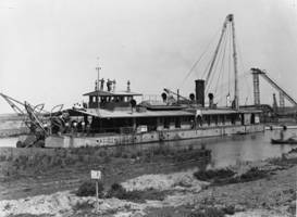
Photo from the irrigation works of the Giannitsa Lake, carried out by the american company New York Company Foundation
The constant shift of the riverbeds, the changes in the head of the deltaic formations and their torrential flow have created –in the 20th century- a new extensive fertile plain and the largest deltaic formation in the country. Over the last fifty years, the reduction of water and alluvia from all rivers has stopped the delta from evolving.
SOURCES
Poulos S.E., G.Th. Chronis, M.B. Collins, V. Lykousis, 2000. Thermaikos Gulf Coastal System, NW Aegean Sea: an overview of waterrsediment fluxes in relation to air–land–ocean interactions and human activities. Journal of Marine Systems 25_2000. 47–76.
Ghilardi, M., Kunesch S., M. Styllas, E. Fouache, 2007. Reconstruction of Mid –Holocene sedimentary environments in the central part of the Thessaloniki plain (Greece), based on microfaunal identification, magnetic susceptibility and grain-size analyses. In press Geomorphology 2007.
Konstantinidis, K.A., 1989. Land Reclamation Project of the Plain of Thessaloniki. Geotechnical Chamber of Greece, Thessaloniki, 186 pp.in Greek.